Intro
Date: 8–11 April 2025
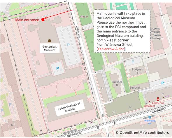
Venue: Polish Geological Institute–National Research Institute, Geological Museum building. Rakowiecka 4, Warsaw, Poland
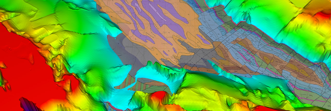
Subsurface: 3D geology of the city of Warsaw, Framework geological model of Poland
The main theme for this conference will be new frontiers and challenges in geomodelling. We would like to focus on latest advances in Geological Surveys Organisations (GSOs), including forward-looking subjects such as uncertainties, model visualisation and delivery. We also want to draw attention to activities we need to embrace beyond surfaces, geobodies and voxel modelling, by focussing on applications (e.g. resources and risks).
Background
Over the past years, GSOs proofed their modelling capabilities in various geoscientific fields while applying different modelling methods. In addition, many initiatives from academia or GSOs have been dealing with the development of new software tools and modelling approaches to improve and simplify 3D modelling. As GSOs are now able to produce high-quality 3D geological models, the next steps should be addressed. Most importantly: How to add value to the models and how to integrate them into an overall lifecycle of GSOs’ strategies, project initiation, execution, outputs and impact? GSOs need to concentrate on this topic, if we want our models to benefit stakeholders and the society at large.
Questions related to this topic could be:
- How to shift from short-term static output (3D models) to long-term dynamic outcome (benefit for stakeholders)?
- How to enable the stakeholders to contribute to the value stream?
- What do GSOs need to change or adapt to, to stay relevant in terms of the three-dimensional description of the subsurface?
- Do GSOs need to produce multi-purpose for a wide range of applications or single-purpose models for specific usage only?
- How can GSOs maximise the benefit of 3D geological models beyond their first intended use? i.e. unlocking their potential for downstream utilisation?
- How to "open" geological 3D models to other disciplines covering the subsurface (e.g. BIM, spatial planning, etc.)?
- What are the challenges GSOs need to tackle related to such questions?
Main Themes
Communicating geological models (including visualization).
This session addresses the critical challenges of visualizing and effectively communicating 3D geological models to diverse stakeholders. It aims to inspire discussions on best practices, innovative solutions, and emerging technologies that make geological models more accessible and impactful, even for audiences with limited or no Earth Sciences background. Geological Survey Organizations are increasingly recognizing the importance of visualizing scientific data to support science-based decision-making for sustainable resource development and public safety.
Communicating and justifying a need for basic, general-purpose geomodelling.
This session will explore how to communicate the importance of basic, general-purpose geomodeling in geological sciences, emphasizing its foundational role in various geological applications such as resource exploration, environmental management, and hazard assessment.
Novel methodologies and approaches to geomodelling.
The field of geological modeling is rapidly evolving with the integration of cutting-edge technologies and innovative methodologies. This session invites abstracts that explore novel approaches to geological modeling, emphasizing new techniques, methodologies, and tools that enhance the accuracy, efficiency, and scalability of geomodels.
New challenges and solutions in urban geology modelling.
This session focuses on the challenges of urban geological modeling and discusses current best practices and innovative ideas. We aim to cover both technical modelling aspects, the integration of geology, man-made deposits and objects, as well as active stakeholder engagement.
New challenges and solutions in geomodelling for clean, efficient and at-scale energy systems and mining.
This session will address the evolving role of geomodeling in the development of sustainable and efficient energy systems and mining operations. As the demand for clean energy sources and responsible resource extraction grows, innovative geological modeling techniques are critical to optimize exploration, production, and management of natural resources.
New challenges and solutions in geomodelling for meeting civil society needs (e.g. resilience to floods, securing clean and sufficient water, stable building sites, managing competing uses of underground space).
This session will focus on the critical role of geomodelling in addressing civil society’s pressing needs, particularly in relation to natural hazards, resource management, and urban development. As populations grow and climate change intensifies, effective geological modeling is essential for building resilient infrastructure, securing water resources, and managing underground space. The session will explore how advanced geological models can help mitigate risks, optimize land use, and promote sustainable development.
Program
The program is divided into conference blocks (talks, poster sessions and break-out session), accompanied by two excursions and three social events. Yo can download it here.
|
GENERAL PROGRAM |
||||||||||
|
|
April, 8 |
April, 9 |
April, 10 |
April, 11 |
||||||
|
Tue |
Wed |
Thu |
Fri |
|||||||
|
6:30-7:30 |
Field trip start 7:30 |
wake-up walk birdwatching |
wake-up walk birdwatching |
wake-up run |
||||||
|
8:00-8:30 |
Full day field trip
Leaders: |
coffee and registration |
coffee |
coffee |
||||||
|
8:30-9:00 |
session "Communicating geological models (including visualization)" |
sessions "Novel methodologies and approaches to geomodelling" and "New challenges and solutions in geomodelling for clean, efficient and at-scale energy systems and mining" |
||||||||
|
9:00-11:00 |
official introduction |
|||||||||
|
country updates |
||||||||||
|
11:00-11:30 |
coffee & cake |
coffee & cake |
coffee & cake |
|||||||
|
11:30-13:00 |
poster madness |
session "New challenges and solutions in geomodelling for meeting civil society needs" |
session "Communicating and justifying a need for basic, general-purpose geomodelling" +thanks, summing up & outlook |
|||||||
|
13:00-14:00 |
lunch |
lunch |
lunch |
|||||||
|
14:00-15:30 |
city tour (in the city centre, ending at the dinner place) |
Introduction (room 15) & discussions in breakout groups |
|
|||||||
|
15:30-16:30 |
coffee, cake, networking, software demonstrations |
|
||||||||
|
16:30-18:00 |
session "New challenges and solutions in urban geology modelling" |
|
||||||||
|
18:00-21:00 |
Icebreaker |
shared-cost dinner |
conference dinner |
|||||||
General Info
Venue: Polish Geological Institute – National Research InstituteRakowiecka 4, 00-975 Warsaw, Poland
Date:
8th April: field trip to Holy Cross Mountains & icebreaker event
9th-11th April: conference
Orientation:
Please refer to the separate Events document for locations of other events.
Travel:
Warsaw Chopin Airport as well as Central Train Station is only ca. 20 min from the city centre & Polish Geological Institute by bus, train or taxi. You can plan your route via: https://jakdojade.pl/warszawa
Public transport in Warsaw is generally well-organized, timely (as long as you avoid buses at rush hours) and inexpensive. Tickets are available from ticket-machines installed at many bus/tram stops, in metro stations and onboard trams & buses (onboard machines accept card payments only, drivers do not sell tickets). Tickets can also be purchased in jakdojade.pl android app, which is as well handy for planning your route.
Please note that the Rakowiecka street between Puławska and Aleje Niepodległości is currently a construction site for the new tramline, so there is very limited traffic. Please let us know if you plan to arrive by car, so we could advice you on the current access options.
Card payment is accepted almost everywhere no matter how little you want to spend (including at many street vendors selling vegetables and alike) so you might not need cash at all. Otherwise cash machines are numerous and you can also withdraw cash in a Żabka (6-23 convenience stores located at almost every block) as long as you also buy any item at the time.
Information for Presenters
Country updates:
Country updates: 3 min, max. 3 slides per country (Wednesday 9th April, ca. 9:45–11:00 hrs), screen format 16/9, please focus on the future rather than the history of your organization in the area of 3D geomodelling.
Posters:
1 min, 1 slide per poster for oral presentation at the poster madness session (Wednesday 9th April, 11:30–12:00hrs), screen format 16/9, please briefly introduce your poster to the audience.
Posters themselves shall be vertical outlay and measure max. 70 width x 100 height cm (a bit more than A1 pagesize, but less than A0). Please print your poster and bring it with you to the meeting. Fixing your poster will be possible from Wednesday morning, preferably during registration. Afterwards posters will be on display for the entire duration of the meeting.
Oral sessions:
12 min + 3 min for questions per talk (sessions on Thursday and Friday 10–11 April), screen format 16/9; please aim to include not more than 15 slides.
Software demonstrations:
15 min presentation of each software, regular presentation or hands-on live demo, screen format 16/9.
Please mail your slides (preferred format .ppt or .pptx but we can accommodate others) to: Ten adres pocztowy jest chroniony przed spamowaniem. Aby go zobaczyć, konieczne jest włączenie w przeglądarce obsługi JavaScript. and Ten adres pocztowy jest chroniony przed spamowaniem. Aby go zobaczyć, konieczne jest włączenie w przeglądarce obsługi JavaScript. (cc) by the 3rd of April at the latest.
Contact

Ten adres pocztowy jest chroniony przed spamowaniem. Aby go zobaczyć, konieczne jest włączenie w przeglądarce obsługi JavaScript.
+48224592130
Ten adres pocztowy jest chroniony przed spamowaniem. Aby go zobaczyć, konieczne jest włączenie w przeglądarce obsługi JavaScript.
+48224592701
Download PDFs
Downloadable attachements are listed below:
›| 5307 kB | 2025-04-07 | |
| 5716 kB | 2025-04-23 | |
| 13607 kB | 2025-04-07 | |
| 2038 kB | 2025-04-23 |